
Introducing the Harry & Marilyn Fisher Preserve at Pompadour Bluff
Watch presentations on the dynamic ecology of Pompadour Bluff.
Pompadour Bluff, a dramatic rocky landform just east of Ashland in the Cascade Foothills, is an intriguing, inaccessible mystery for people passing by on I-5 or Indian Memorial Highway. On certain spring days, the bluff can be seen from downtown Ashland with a rainbow arcing over green misty slopes and cliffs. In late spring, the grassland surrounding the bluff flashes its “purple mountains majesty” as vetch flowers brighten the slopes. Early Euro-American settlers named the bluff after a popular hair style, but the first peoples of the area, the Shasta and Latgawa, likely had a special name, a name we hope to discover.
Harry and Marilyn Fisher Preserve at Pompadour Bluff in spring. Photo by Donna Rhee.
The bluff was so iconic that in 2011 Su Rolle, a former SOLC staff member, sent a hand-written letter to the owner, Harry Fisher, asking him if he might want to consider conservation for his iconic land. His response was a surprise: SOLC was already in his will—his intention was to donate the land as the Harry and Marilyn Fisher Preserve for long-term protection. Harry Fisher worked outside, caring for the land up to his 90th year. He loved good whiskey, cigars, and his property, so much so that he worked together with SOLC to ensure that future generations will be able to enjoy the view of the bluff —and its dynamic ecology—that we value today.
Pompadour Bluff cliffs. Photo by Richard Jacquot.
A Little Bit Basin & Range, A Little Bit Rogue Valley Oak Woodland & Grassland
Hearing the cascading trill-song of a Canyon Wren is a surprise in the Rogue Valley, a bird more common in arid canyonlands to the east and southwest. A Black-billed Magpie flits through the oaks as Rock Wrens forage in the rocks. Growing in and around the bluff are western juniper trees, rabbitbrush, and robust clumps of bluebunch wheatgrass. Pompadour Bluff is a little bit basin and range.
Old oak. Photo by Robert Mumby.
Oak woodland in autumn. Photo by Richard Jacquot.
On the flanks of the bluff, some of the oak trees have been alive since the 1830s. This spring, a Red-tailed Hawk pair successfully raised a baby in one of these grand oaks. This beautiful old woodland is carpeted with spring flowers, including a large population of five species of biscuitroots. Adjacent to the woodland is an intact remnant of Rogue Valley grassland—instead of nonnative pasture grasses or annual grasses—the northeast slope is surprisingly full of bunchgrasses and forbs such as Lemmon’s needlegrass, squirreltail, mulesears, catsears, and the endemic Southern Oregon Buttercup, only known in Jackson County. Declining birds associated with valley floor oaks and grasslands are common—like Western Meadowlarks and Western Bluebirds. Grassland raptors are also abundant. Pompadour Bluff is a little bit of undeveloped Rogue Valley Oak and grassland.
Rock Wren at Pompadour Bluff. Photo by Frank Lospalluto.
An Iconic Rocky Bluff Supports Cliff-Life & Rare Species
The cliffs are primarily composed of the Payne Cliff Formation made up of former river deposits. Conglomerate rocks, a mix of sediments, gravels and cobbles, as they weather lose large cobbles providing sheltering caves for birds and small mammals. At the top, where the cobbles weathered out, rocky vernal pools collect rainwater during the winter. Nesting in the cliffs, a landform of special importance to wildlife, are Barn Owls, Common Ravens, and a sky-full of flitting Violet-green Swallows. While we have just begun investigating the property, a few rare surprises have been discovered including a rare rock lichen and possibly species that have not been previously described. The cliffs also support two rare moss species. An unusual shrub, hollyleaf redberry, was also recently found here. This is the first record of this rare shrub in the Rogue Valley. Prior to this find, it was only known in Oregon growing at a few locations in the Applegate Valley and along Scotch Creek in the Klamath Watershed portion of the Cascade-Siskiyou National Monument.
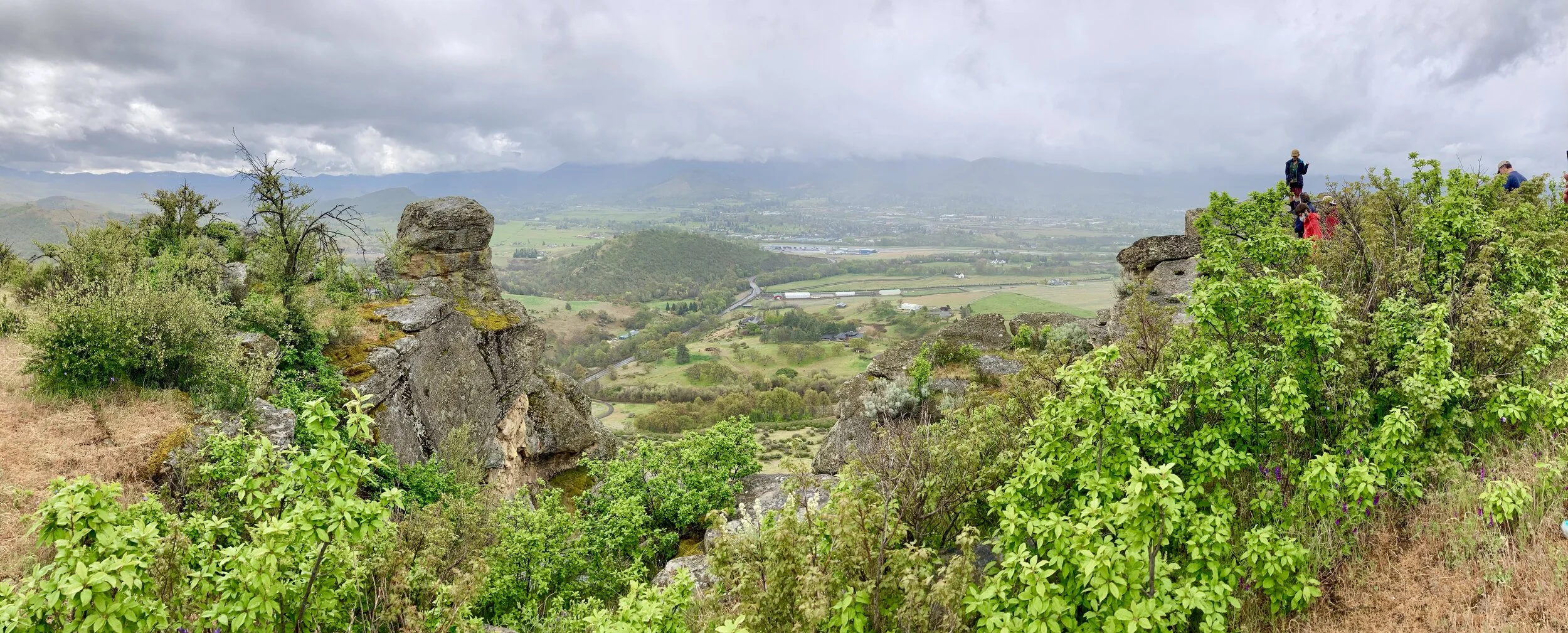
View looking north toward the lower Bear Creek valley. Photo by Robert Mumby.
The Top is the Tops!
From the top, the view of the southern Bear Creek Valley is incomparable. A place of beauty, a place for studying geography. The peaks of Wagner Butte and Mt. Ashland of the older Siskiyous extend down along forested slopes to the valley floor. Pilot Rock serves as a sentinel to the south while other Cascade peaks, like Grizzly Peak, frame the view to the north. The green to golden grasses of the Cascade foothills edge towards the horizon. This is a view to share.
Cave in bluff. Photo by SOLC staff.
Our Vision
With help from volunteers, SOLC will care for, conserve and cherish Pompadour Bluff. We will work toward sharing this iconic place while also protecting its biodiversity and conservation values. We envision occasional hikes, stewardship events and eventually, days the land may be open to school groups and interested visitors.
Support the Bluff
Please consider contributing to help us begin the essential upgrades necessary to safely facilitate stewardship and community engagement. You can donate on our website, by calling 541-482-3069, or by mailing a check to SOLC, PO Box 954, Ashland, OR 97520.
Watch presentations on the dynamic ecology of the Harry and Marilyn Fisher Preserve at Pompadour Bluff.
*Conservation values
*Geology
*Special lichens and mosses
*A project update
Banner image: View from on top of Pompadour Bluff. By Harry Brindley.